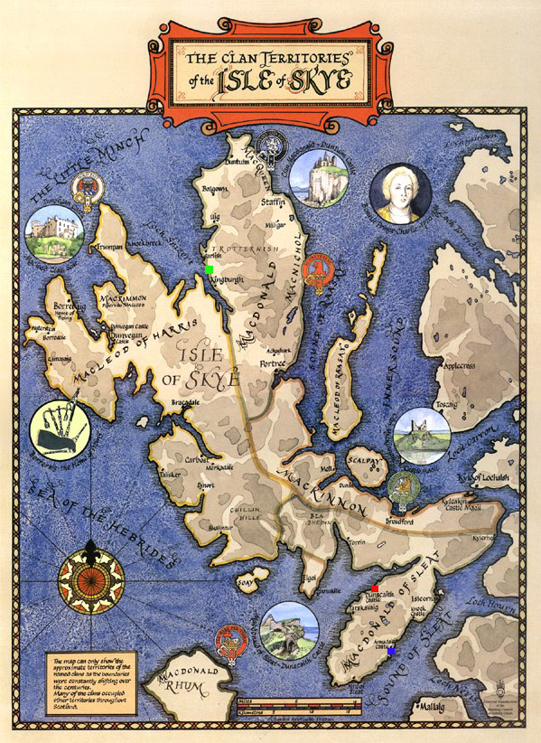
This clan map shows clearly the geography of the Isle of Skye. I placed small colored squares on important locations.
In the top center area is a green square representing the approximate location of Caisteal Uisdean. This was the last castle built on Skye and was built by a man named Hugh who was a direct descendent of Hugh of Sleat. The general vicinity of the green square is also the approximate place that Bonnie Prince Charlie came "over the sea to Skye", in the company of Flora McDonald, a Clan Uisdean member who helped him escape. Charlie is known to have walked from just above Caisteal Uisdean to a location below it. He undoubtably held to the coastline as he was being hunted by the English. He most likely walked very near Caisteal Uisdean during his escape. Perhaps he took repose there for awhile.
Further above this castle, in this area known as the Trotternish Peninsula, stands another clan castle, Duntulm, which was said to be the place the children of the chiefs would go to learn Latin and Music and other fine arts. Trotternish was in contention many times between the Macleods, whose territory is shown just to the right, and the McDonalds of Skye, known as Clan Uisdean.
Moving to the bottom of the map you will see two squares on the strip of land known as the Sleat Peninsula. The red square marks the approximate location of Dunscaith Castle, where the McUisdean name, for all intents and purposes, began. The castle is now in ruins but I have much information to share on it, later.
The blue square marks the approximate location of the Clan Donald Center, where I studied in 1999 and 2000 to uncover our family history. This is the site of Armadale Castle, another castle of Clan Donald. The four castles mentioned are the principle ones in Clan Donald history although there are a few others that dot the landscape and shoreline of Skye. The ferry to the mainland leaves from the blue square area, while the bridge is built further to the northeast.
Skye receives the tail end of the warmth of the Gulf Stream, and is a tourist attraction today. It was a choice piece of real estate for the Lords of the Isles to own back in the days of Hugh.